LARGE DIGITAL TWINS
- Projects



Does a topographer have to enter by sight?
We often expect that in all topographic maps the coordinate system, projection, scale are included and we assume the accuracy of the data represented, but, having said that, if it looks good at first glance, is it already a good product?
In its representation it must go a little beyond data taken objectively, resulting from specific technical knowledge, striving to represent the terrain in the most faithful way to reality and at the same time as understandable as possible.
As an example, let's analyze a section of road with a closed curve excavated in a natural slope. The data collected in Figure 1 are limited to the data taken from the road, without providing data from its immediate surroundings and in terms of representation, a curve composed of straight sections is observed that would be typical of an automatic drawing without revision.
Otherwise, the unsmoothed contour lines do not transport us to the survey site, as the resulting triangulation has caused them to be drawn with sections with vertices caused by the digital model itself, moving it away from reality. Likewise, the accumulation of curves in some of these triangles does not reflect the continuity that they most likely should represent.
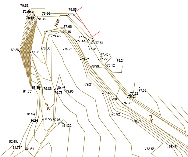
Figure 1
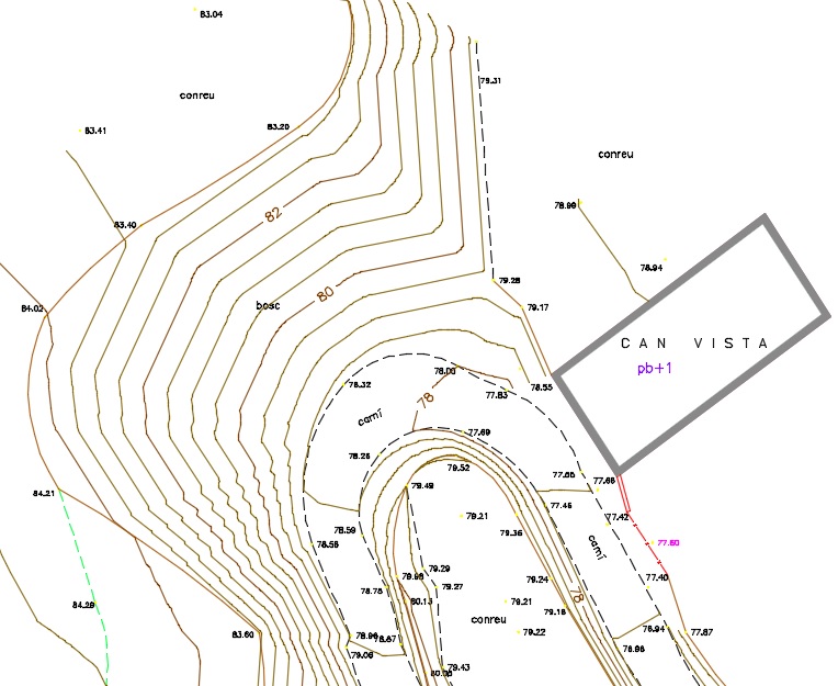
Figure 2
In figure 2, we have the same section but with some differences in its representation. The data collection goes a little further thanthe own path i the highest density of points allows the topographer who has been there to represent the curve as such, that of a rural road where a cart or even other types of vehicles should be able to turn. The better distribution of the points also allows the contour lines of the road to show us the true slope of the road, which in addition to being constant, is much more credible than in figure 1.
On the inner part of the path, we understand the reason for some very sharp curves, seeing the breaking line represented by a small foot of slope.
Another detail that we can observe is the readability of the texts. If the texts are placed in places where they do not intersect with the rest of the elements of the drawing and are oriented, they are easier to read and make reading faster.
Thus, we see how a more accurate representation not only helps us understand the topographic map but is an indicator that what is represented there is more faithful to reality and answers the question we asked ourselves as a statement: Yes, a topographic map must enter through the eyes and the fact is that in the figure of the topographer there is also that of a modest artist who guarantees realism.
Roger Sant Vidal